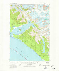
1961 Map of Mount Fairweather C-5
USGS Topo · Published 1977About this map
Lituya Bay dominates this coastal survey, where the glacial influence of the Glacier Bay National Monument meets the Gulf of Alaska. The map records a landscape of immense natural force, defined by the Lituya Glacier feeding into Gilbert Inlet and the North Crillon Glacier pressing toward the sea. At the center of the bay, Cenotaph Island and Three Saints Point serve as landmarks in an area notorious for its geological activity.
Find a feature on this map
32 named features on this map. Tap any name to fly to it.
Don’t see what you’re looking for? This feature index may not catch every label — zoom into the map to look around manually.
Map Details
Editions of this 1961 Mount Fairweather C-5 Map
2 editions found
Other maps of this area

1951 · Mt Fairweather
USGS Topo · 1:250,000

1961 · Mount Fairweather D-4
USGS Topo · 1:63,360

1961 · Mount Fairweather D-6
USGS Topo · 1:63,360

1961 · Mount Fairweather D-5
USGS Topo · 1:63,360

1961 · Mount Fairweather C-4
USGS Topo · 1:63,360
1961 · Mount Fairweather C-6
USGS Topo · 1:63,360
1961 · Mt Fairweather B-4
USGS Topo · 1:63,360

1961 · Mount Fairweather C-5
USGS Topo · 1:63,360

1961 · Mt Fairweather
USGS Topo · 1:250,000
2017 · Mount Fairweather D-4 SW
USGS Topo · 1:25,000