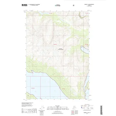
2017 Map of Sumdum C-4 NW
USGS Topo · Published 2017About this map
Endicott Arm carves into the Alaskan wilderness on this 2017 survey, defining the coastal boundary where the sea meets the steep, glaciated terrain of the Tongass National Forest. The map documents a sparsely populated region of Southeast Alaska, capturing the intersection of the Hoonah-Angoon Census Area and the Petersburg Borough. The dramatic topography shown here highlights the transition from marine environments to high-elevation forest land. This edition provides a precise baseline of the shoreline and internal boundaries within the Tongass National Forest during the early 21st century, focusing on the natural geography and administrative lines of this remote coastal area.
Find a feature on this map
4 named features on this map. Tap any name to fly to it.
Don’t see what you’re looking for? This feature index may not catch every label — zoom into the map to look around manually.
Map Details
Editions of this 2017 Sumdum C-4 NW Map
This is the sole edition of this map. No revisions or reprints were ever made.
Other maps of this area

1948 · Sumdum C-5
USGS Topo · 1:63,360

1948 · Sumdum D-5
USGS Topo · 1:63,360

1951 · Sumdum C-5
USGS Topo · 1:63,360

1952 · Sumdum
USGS Topo · 1:250,000

1955 · Sumdum D-5
USGS Topo · 1:63,360

1960 · Sumdum D-4
USGS Topo · 1:63,360

1961 · Sumdum C-4
USGS Topo · 1:63,360

1961 · Sumdum
USGS Topo · 1:250,000
1994 · Sumdum D-5
USGS Topo · 1:63,360
1994 · Sumdum D-4
USGS Topo · 1:63,360