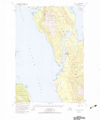
1950 Map of Juneau A-3
USGS Topo · Published 1983About this map
The Mansfield Peninsula on Admiralty Island dominates this 1950s-era coastal survey, revealing a landscape defined by maritime industry and resource extraction. At Hawk Inlet, a concentrated hub of activity includes a Cannery, an Aqueduct, and a Seaplane Base vital for regional transport. Nearby, the Admiralty Mine and a Tramway indicate the rugged logistical efforts required for mineral exploration on these remote slopes. The map traces the intricate shoreline where Chatham Strait and Lynn Canal meet, documenting isolated Cabins at Funter Bay and navigational markers like the Light at Hanus Reef. This record captures a period when the Alaskan panhandle's economy relied heavily on coastal canning and mining outposts, connected more by water and air than by terrestrial roads.
Find a feature on this map
43 named features on this map. Tap any name to fly to it.
Don’t see what you’re looking for? This feature index may not catch every label — zoom into the map to look around manually.
Map Details
Editions of this 1950 Juneau A-3 Map
3 editions found

Other maps of this area

1947 · Juneau B-3
USGS Topo · 1:63,360

1947 · Juneau B-2
USGS Topo · 1:63,360

1948 · Juneau B-4
USGS Topo · 1:63,360

1948 · Juneau A-3
USGS Topo · 1:63,360

1948 · Juneau A-4
USGS Topo · 1:63,360

1948 · Sitka D-3
USGS Topo · 1:63,360

1948 · Sitka D-2
USGS Topo · 1:63,360

1948 · Sitka D-4
USGS Topo · 1:63,360

1949 · Juneau B-3
USGS Topo · 1:62,500

1949 · Juneau B-2
USGS Topo · 1:62,500