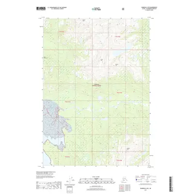
2017 Map of Sumdum A-4 NE
USGS Topo · Published 2017About this map
The Farragut River winds through the heart of the Tongass National Forest, carving a wide glacial valley through the formidable Coast Mountains. This 2017 survey by the U.S. Geological Survey captures the intricate drainage patterns and expansive ice fields that characterize the Petersburg Borough wilderness. High-altitude landmarks such as Lincoln Peak and Grant Peak define the northern skyline, while the southern reaches are anchored by the Franklin Peaks. The map provides a precise view of the braided river channels and the sheer verticality of Stanton Peak, illustrating the scale of the Alaskan landscape before it meets the coastal inlets. Researchers can trace the complex network of unnamed streams and seasonal runoffs that feed into the primary river system, reflecting the untouched character of this federal forest land.
Find a feature on this map
13 named features on this map. Tap any name to fly to it.
Don’t see what you’re looking for? This feature index may not catch every label — zoom into the map to look around manually.
Map Details
Editions of this 2017 Sumdum A-4 NE Map
This is the sole edition of this map. No revisions or reprints were ever made.
Other maps of this area

1943 · Sumdum B-4
USGS Topo · 1:63,360

1948 · Sumdum A-4
USGS Topo · 1:63,360

1948 · Sumdum B-4
USGS Topo · 1:63,360

1951 · Sumdum A-4
USGS Topo · 1:63,360

1952 · Sumdum
USGS Topo · 1:250,000

1961 · Sumdum A-3
USGS Topo · 1:63,360

1961 · Sumdum B-3
USGS Topo · 1:63,360

1961 · Sumdum
USGS Topo · 1:250,000

1996 · Sumdum B-3
USGS Topo · 1:63,360

1996 · Sumdum B-4
USGS Topo · 1:63,360