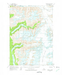
1961 Map of Sumdum B-3
USGS Topo · Published 1975About this map
Tongass National Forest defines the wilderness character of this Southeast Alaska coastal region, where ice and seawater meet in a dramatic landscape. The map captures a moment in the mid-twentieth century when the reach of the Dawes Glacier and North Baird Glacier shaped the surrounding geography, marked by extensive fields of crevasses. Inland, high-elevation landmarks such as Maury Peak look down over isolated water bodies including Glory Lake and Farragut Lake. The lack of roads or established trails on this sheet underscores the isolation of Endicott Arm and its surrounding fjords, reachable only by water or air. This survey provides a baseline of glacial positioning and shoreline features before subsequent decades of environmental change, serving as a critical record for those studying the shifting ice of the Alaskan panhandle.
Find a feature on this map
9 named features on this map. Tap any name to fly to it.
Don’t see what you’re looking for? This feature index may not catch every label — zoom into the map to look around manually.
Map Details
Editions of this 1961 Sumdum B-3 Map
2 editions found

Other maps of this area

1943 · Sumdum B-4
USGS Topo · 1:63,360

1948 · Sumdum A-4
USGS Topo · 1:63,360

1948 · Sumdum B-4
USGS Topo · 1:63,360

1951 · Sumdum A-4
USGS Topo · 1:63,360

1952 · Sumdum
USGS Topo · 1:250,000

1961 · Sumdum A-2
USGS Topo · 1:63,360

1961 · Sumdum C-3
USGS Topo · 1:63,360

1961 · Sumdum B-2
USGS Topo · 1:63,360

1961 · Sumdum C-4
USGS Topo · 1:63,360

1961 · Sumdum A-3
USGS Topo · 1:63,360