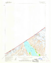
1961 Map of Skagway A-6
USGS Topo · Published 1968About this map
Glacier Bay National Monument dominates this mid-century survey, centering on the deep waters of Tarr Inlet where it meets the face of the Margerie Glacier. The map documents a stark landscape of ice and stone along the international border, where the Canada United States boundary is defined by high-altitude points including Mt Forde and Boundary Peak 161. To the northeast, the Rendu Glacier flows toward the coast from the slopes of Mt Barnard. This topography, based on aerial photographs from 1948 and 1954, captures the exact position of these massive ice flows and the intricate network of crevasses that defined their surfaces during the early 1960s. It serves as a precise record of glacial extent and maritime depth data compiled by the Usc&GS before more modern shifts in the shoreline.
Find a feature on this map
12 named features on this map. Tap any name to fly to it.
Don’t see what you’re looking for? This feature index may not catch every label — zoom into the map to look around manually.
Map Details
Editions of this 1961 Skagway A-6 Map
2 editions found
Other maps of this area

1951 · Mt Fairweather
USGS Topo · 1:250,000

1952 · Skagway
USGS Topo · 1:250,000

1961 · Skagway A-7
USGS Topo · 1:63,360

1961 · Mount Fairweather D-4
USGS Topo · 1:63,360
1961 · Skagway A-6
USGS Topo · 1:63,360
1961 · Skagway A-5
USGS Topo · 1:63,360

1961 · Mount Fairweather D-3
USGS Topo · 1:63,360

1961 · Mt Fairweather
USGS Topo · 1:250,000

1961 · Skagway
USGS Topo · 1:250,000
2017 · Skagway A-5 SW
USGS Topo · 1:25,000