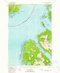
1948 Map of Mount Fairweather A-2
USGS Topo · Published 1962About this map
Glacier Bay National Monument and the Tongass National Forest meet in this mid-century topographic study of Alaska's coastal wilderness. The landscape is defined by the deep waters of Cross Sound and the intricate coastline of Yakobi Island and the Chichagof Peninsula. Small coastal outposts like Elfin Cove and Bingham Cove serve as markers of human presence at the edge of the Pacific, while the interior is dominated by peaks like Vein Mountain and Mount Althrop. This era of mapping relied on 1948 aerial photography to chart the complex glacial geography of Dicks Arm and the treacherous Inian Pass. The map illustrates a maritime economy dependent on these narrow waterways, showing the relationship between freshwater sources like Hoktaheen Lake and the salt-water channels of Lisianski Inlet and Lisianski Strait.
Find a feature on this map
42 named features on this map. Tap any name to fly to it.
Don’t see what you’re looking for? This feature index may not catch every label — zoom into the map to look around manually.
Map Details
Editions of this 1948 Mount Fairweather A-2 Map
3 editions found
Other maps of this area

1948 · Mount Fairweather A-2
USGS Topo · 1:63,360

1948 · Mount Fairweather B-1
USGS Topo · 1:63,360

1948 · Mount Fairweather B-2
USGS Topo · 1:63,360

1948 · Sitka D-8
USGS Topo · 1:63,360

1948 · Mount Fairweather A-1
USGS Topo · 1:63,360

1950 · Sitka D-8
USGS Topo · 1:63,360

1951 · Sitka D-7
USGS Topo · 1:63,360

1951 · Mt Fairweather
USGS Topo · 1:250,000

1951 · Sitka
USGS Topo · 1:250,000

1952 · Sitka
USGS Topo · 1:250,000