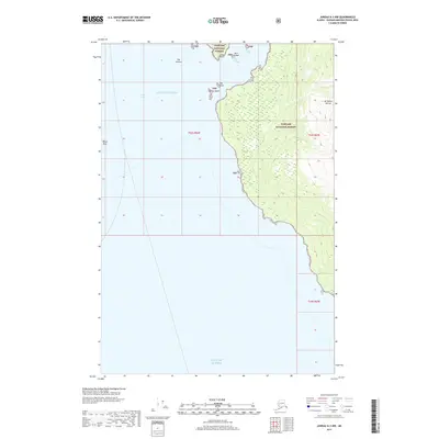
2017 Map of Juneau A-3 NW
USGS Topo · Published 2017About this map
Tongass National Forest covers the coastline of Admiralty Island in this maritime survey, where the steep slopes of Mt Robert Barron descend toward the complex waters of the Gulf of Alaska. The map documents a rugged shoreline defined by navigational hazards and coastal landmarks, from the narrow mouth of Funter Bay to the exposed Hanus Reef in the Lynn Canal. Small island clusters and outcrops such as The Kittens, Rat Island, and Station Island serve as vital reference points along this stretch of the Alexander Archipelago. This 2017 edition provides a clear record of the coastal topography and bathymetric features, including Curlew Ledge and Bare Island, essential for understanding the natural landscape and maritime history of the northern Panhandle.
Find a feature on this map
16 named features on this map. Tap any name to fly to it.
Don’t see what you’re looking for? This feature index may not catch every label — zoom into the map to look around manually.
Map Details
Editions of this 2017 Juneau A-3 NW Map
This is the sole edition of this map. No revisions or reprints were ever made.
Other maps of this area

1947 · Juneau B-3
USGS Topo · 1:63,360

1948 · Juneau B-4
USGS Topo · 1:63,360

1948 · Juneau A-3
USGS Topo · 1:63,360

1948 · Juneau A-4
USGS Topo · 1:63,360

1949 · Juneau B-3
USGS Topo · 1:62,500

1949 · Juneau B-4
USGS Topo · 1:63,360

1950 · Juneau A-3
USGS Topo · 1:63,360

1951 · Juneau
USGS Topo · 1:250,000

1962 · Juneau B-3
USGS Topo · 1:63,360

1962 · Juneau
USGS Topo · 1:250,000