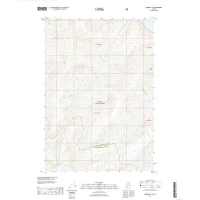
2017 Map of Sumdum D-4 SW
USGS Topo · Published 2017About this map
Tongass National Forest encompasses the vast majority of this landscape, reflecting the remote and undeveloped character of Southeast Alaska in the early 21st century. The map highlights a significant administrative boundary where the Hoonah-Angoon Census Area meets the Petersburg Borough, a line that snakes through the high-elevation terrain of the Coast Mountains. This survey, produced by the U.S. Geological Survey in cooperation with the U.S. Forest Service, documents a region defined by extreme vertical relief and complex glacial topography rather than human settlement. The absence of roads or structures emphasizes the wilderness value of this section of the national forest, providing a precise record of the natural contours and drainage patterns that dictate the geography of this coastal range.
Find a feature on this map
7 named features on this map. Tap any name to fly to it.
Don’t see what you’re looking for? This feature index may not catch every label — zoom into the map to look around manually.
Map Details
Editions of this 2017 Sumdum D-4 SW Map
This is the sole edition of this map. No revisions or reprints were ever made.
Other maps of this area

1948 · Sumdum C-5
USGS Topo · 1:63,360

1948 · Sumdum D-5
USGS Topo · 1:63,360

1951 · Sumdum C-5
USGS Topo · 1:63,360

1952 · Sumdum
USGS Topo · 1:250,000

1955 · Sumdum D-5
USGS Topo · 1:63,360

1960 · Sumdum D-4
USGS Topo · 1:63,360

1961 · Sumdum C-4
USGS Topo · 1:63,360

1961 · Sumdum
USGS Topo · 1:250,000
1994 · Sumdum D-5
USGS Topo · 1:63,360
1994 · Sumdum D-4
USGS Topo · 1:63,360