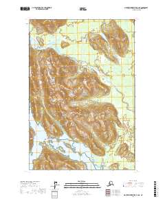
2017 Map of Mount Fairweather B-2 NE
USGS Topo · Published 2017About this map
Glacier Bay National Park dominates this portion of the Alaskan coast, where the massive elevations of the Fairweather Range and the Saint Elias Mountains meet the tidal waters. The topography is defined by dramatic vertical relief, with contour lines indicating steep glacial valleys and peaks that overlook the surrounding wilderness. The Dundas River flows through a broad alluvial corridor, eventually draining into the northern reaches of Dundas Bay. This 2017 survey reflects a landscape largely untouched by permanent human settlement, instead highlighting the complex hydrography and natural boundaries of this protected maritime environment. The intricate shoreline of the bay reveals a network of smaller inlets and wetlands typical of the region's dynamic coastal ecosystems.
Find a feature on this map
9 named features on this map. Tap any name to fly to it.
Don’t see what you’re looking for? This feature index may not catch every label — zoom into the map to look around manually.
Map Details
Editions of this 2017 Mount Fairweather B-2 NE Map
This is the sole edition of this map. No revisions or reprints were ever made.
Other maps of this area

1948 · Mount Fairweather B-1
USGS Topo · 1:63,360

1948 · Mount Fairweather B-2
USGS Topo · 1:63,360

1948 · Mount Fairweather C-1
USGS Topo · 1:63,360

1948 · Mount Fairweather C-2
USGS Topo · 1:63,360

1949 · Mount Fairweather C-1
USGS Topo · 1:63,360

1950 · Mount Fairweather C-2
USGS Topo · 1:63,360

1951 · Mt Fairweather
USGS Topo · 1:250,000

1961 · Mt Fairweather
USGS Topo · 1:250,000
2017 · Mount Fairweather B-1 SW
USGS Topo · 1:25,000
2017 · Mount Fairweather B-1 NW
USGS Topo · 1:25,000