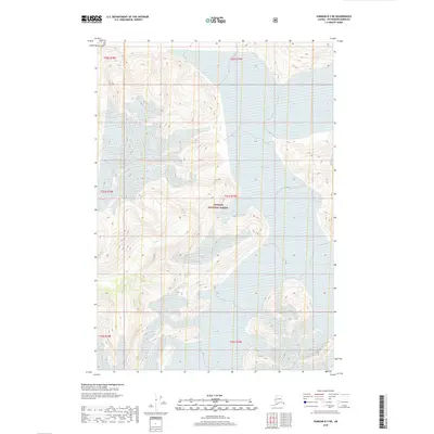
2018 Map of Sumdum B-3 NE
USGS Topo · Published 2018About this map
Dawes Glacier dominates this landscape within the vast protected boundaries of the Tongass National Forest. This 2018 topographic survey illustrates the sheer scale of the ice field as it carves through the mountains of the Petersburg Borough. The map provides a precise record of the glacier's extent and the surrounding ice-scoured terrain, where massive elevation changes are documented by dense contour lines. This is a wilderness defined by its glaciated valleys and the absence of any established roads or human settlements, highlighting the remote character of Southeast Alaska's coastal range.
Find a feature on this map
8 named features on this map. Tap any name to fly to it.
Don’t see what you’re looking for? This feature index may not catch every label — zoom into the map to look around manually.
Map Details
Editions of this 2018 Sumdum B-3 NE Map
This is the sole edition of this map. No revisions or reprints were ever made.
Other maps of this area

1952 · Sumdum
USGS Topo · 1:250,000

1961 · Sumdum C-3
USGS Topo · 1:63,360

1961 · Sumdum B-2
USGS Topo · 1:63,360
1961 · Sumdum C-2
USGS Topo · 1:63,360

1961 · Sumdum B-3
USGS Topo · 1:63,360

1961 · Sumdum
USGS Topo · 1:250,000

1996 · Sumdum B-3
USGS Topo · 1:63,360

2000 · Sumdum C-3
USGS Topo · 1:63,360

2000 · Sumdum B-2
USGS Topo · 1:63,360
2018 · Sumdum B-2 SW
USGS Topo · 1:25,000