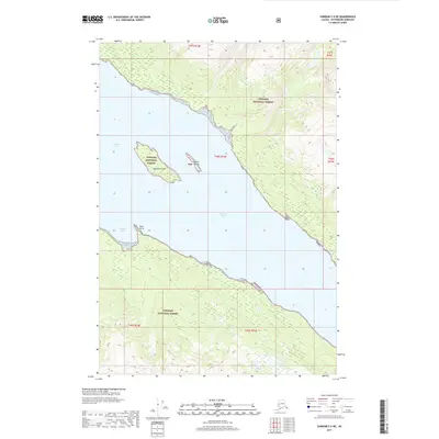
2017 Map of Sumdum C-5 NE
USGS Topo · Published 2017About this map
Endicott Arm carves through the coastal wilderness of the Tongass National Forest in this 2017 topographic study. The landscape is defined by the steep transition from the deep waters of the glacial fjord to the high ridgelines that frame the inlet. Isolated landforms like Sumdum Island and the Bushy Islands sit within the arm, providing navigational landmarks for the maritime traffic that characterizes this part of the Alaska Panhandle. The absence of roads or permanent settlements emphasizes the protected nature of the national forest and the reliance on water-based access. On the southwestern shore, the indentation of Sanford Cove and the protrusion of Rock Point mark significant changes in the coastline's orientation, reflecting the scouring action of past glacial movements across the Unorganized Borough.
Find a feature on this map
12 named features on this map. Tap any name to fly to it.
Don’t see what you’re looking for? This feature index may not catch every label — zoom into the map to look around manually.
Map Details
Editions of this 2017 Sumdum C-5 NE Map
This is the sole edition of this map. No revisions or reprints were ever made.
Other maps of this area

1948 · Sumdum C-5
USGS Topo · 1:63,360

1948 · Sumdum D-5
USGS Topo · 1:63,360

1951 · Sumdum C-5
USGS Topo · 1:63,360

1952 · Sumdum
USGS Topo · 1:250,000

1955 · Sumdum D-5
USGS Topo · 1:63,360

1960 · Sumdum D-4
USGS Topo · 1:63,360

1961 · Sumdum C-4
USGS Topo · 1:63,360

1961 · Sumdum
USGS Topo · 1:250,000
1994 · Sumdum D-5
USGS Topo · 1:63,360
1994 · Sumdum D-4
USGS Topo · 1:63,360