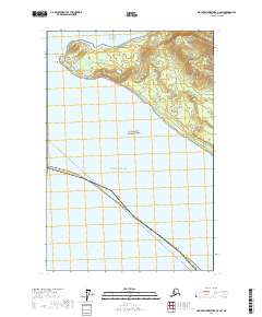
2017 Map of Mount Fairweather C-5 SW
USGS Topo · Published 2017About this map
The coastal wilderness of Glacier Bay National Park meets the Gulf of Alaska on this western edge of the Hoonah-Angoon Census Area. The land is characterized by steep, undeveloped terrain including the prominent twin peaks of The Paps and the treacherous maritime hazards of Passage Rock and Cormorant Rock near Harbor Point. Several drainage systems, most notably Steelhead Cr and Whale Cr, carve through the dense landscape toward the sea. A maritime transit corridor, marked as Pelican - Juneau, cuts across the gulf waters, illustrating the vital water-based connections necessary in this roadless region. The map provides a detailed look at the interface between the open ocean and the protected parklands at Anchorage Cove.
Find a feature on this map
17 named features on this map. Tap any name to fly to it.
Don’t see what you’re looking for? This feature index may not catch every label — zoom into the map to look around manually.
Map Details
Editions of this 2017 Mount Fairweather C-5 SW Map
This is the sole edition of this map. No revisions or reprints were ever made.
Other maps of this area

1951 · Mt Fairweather
USGS Topo · 1:250,000
1961 · Mount Fairweather C-6
USGS Topo · 1:63,360

1961 · Mount Fairweather C-5
USGS Topo · 1:63,360

1961 · Mt Fairweather
USGS Topo · 1:250,000
2017 · Mount Fairweather C-5 NW
USGS Topo · 1:25,000
2017 · Mount Fairweather C-5 SE
USGS Topo · 1:25,000
2017 · Mount Fairweather C-6 SE
USGS Topo · 1:25,000
2017 · Mount Fairweather C-5 NE
USGS Topo · 1:25,000
2017 · Mount Fairweather B-4 OE W NE
USGS Topo · 1:25,000
2017 · Mount Fairweather C-6 NE
USGS Topo · 1:25,000