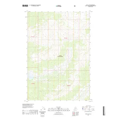
2021 Map of Sitka D-2 NW
USGS Topo · Published 2021About this map
Tongass National Forest dominates this Alaskan landscape, characterized by high-elevation terrain and significant coastal drainage systems. The survey reveals a complex hydrological network defined by the presence of Lake Kathleen and the winding course of Wheeler Cr, which cuts through the dense forest sections of t45s r66e and t45s r67e. Unlike more developed regions, this area shows a landscape primarily managed by the U.S. Geological Survey for conservation and environmental study, with no major roads or settlements indicated. The map provides a precise look at the township and range lines within the Sitka D-2 NW quadrangle, offering essential data for those studying the remote wilderness and water resources of the Hoonah-Angoon Census Area.
Find a feature on this map
7 named features on this map. Tap any name to fly to it.
Don’t see what you’re looking for? This feature index may not catch every label — zoom into the map to look around manually.
Map Details
Editions of this 2021 Sitka D-2 NW Map
This is the sole edition of this map. No revisions or reprints were ever made.
Other maps of this area

1948 · Juneau A-3
USGS Topo · 1:63,360

1948 · Sitka D-3
USGS Topo · 1:63,360

1948 · Sitka D-2
USGS Topo · 1:63,360

1950 · Juneau A-3
USGS Topo · 1:63,360

1951 · Juneau
USGS Topo · 1:250,000

1951 · Juneau A-2
USGS Topo · 1:63,360

1951 · Sitka
USGS Topo · 1:250,000

1951 · Sitka D-3
USGS Topo · 1:63,360

1951 · Sitka D-2
USGS Topo · 1:63,360

1952 · Sitka
USGS Topo · 1:250,000