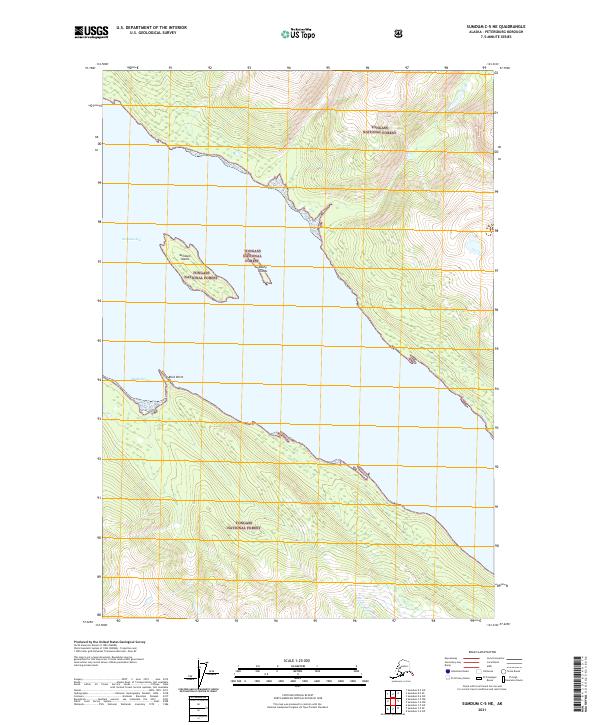
2021 Map of Sumdum C-5 NE
USGS Topo · Published 2021About this map
Tongass National Forest dominates this coastal landscape in the Petersburg Borough, where the glacial waters of Endicott Arm carve through the terrain. The map highlights the maritime geography of the region, specifically focusing on the navigable waters and the hazardous outcroppings that define this stretch of the Alaska coast. Inland, the topography rises sharply from the shoreline, with contours marking the steep ascent into the protected forest lands. Features like Sumdum Island and the Bushy Islands sit at the mouth of smaller inlets, providing essential landmarks for coastal navigation. On the western shore, Sanford Cove and the prominent Rock Point represent the interface between the deep fjord-like waters and the dense, protected wilderness. The survey documents the area as it appeared in 2021, capturing the precise shoreline and elevation data of this remote maritime environment.
Find a feature on this map
12 named features on this map. Tap any name to fly to it.
Don’t see what you’re looking for? This feature index may not catch every label — zoom into the map to look around manually.
Map Details
Editions of this 2021 Sumdum C-5 NE Map
This is the sole edition of this map. No revisions or reprints were ever made.
Other maps of this area

1948 · Sumdum C-5
USGS Topo · 1:63,360

1948 · Sumdum D-5
USGS Topo · 1:63,360

1951 · Sumdum C-5
USGS Topo · 1:63,360

1952 · Sumdum
USGS Topo · 1:250,000

1955 · Sumdum D-5
USGS Topo · 1:63,360

1960 · Sumdum D-4
USGS Topo · 1:63,360

1961 · Sumdum C-4
USGS Topo · 1:63,360

1961 · Sumdum
USGS Topo · 1:250,000
1994 · Sumdum D-5
USGS Topo · 1:63,360
1994 · Sumdum D-4
USGS Topo · 1:63,360