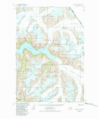
1960 Map of Sumdum D-4
USGS Topo · Published 1984About this map
Tongass National Forest dominates this coastal Alaskan landscape, where the dramatic meeting of ice and sea is meticulously documented through data from 1948 and 1961 surveys. The glacial activity of Sawyer Glacier and South Sawyer Glacier has carved deep inlets, most notably the winding waters of Tracy Arm. This 1960 edition, with revisions through 1984, captures the formal designation of the Tracy Arm-Fords Terror Wilderness following the Alaska National Interest Lands Conservation Act. The map also traces the international boundary between the United States and Canada, marking the divide between Alaska and British Columbia along the high ridges above the ice fields.
Find a feature on this map
7 named features on this map. Tap any name to fly to it.
Don’t see what you’re looking for? This feature index may not catch every label — zoom into the map to look around manually.
Map Details
Editions of this 1960 Sumdum D-4 Map
4 editions found
Other maps of this area

1948 · Sumdum C-5
USGS Topo · 1:63,360

1948 · Sumdum D-5
USGS Topo · 1:63,360

1951 · Taku River A-4
USGS Topo · 1:63,360

1951 · Taku River A-5
USGS Topo · 1:63,360

1951 · Sumdum C-5
USGS Topo · 1:63,360

1952 · Sumdum
USGS Topo · 1:250,000

1953 · Taku River
USGS Topo · 1:250,000

1955 · Sumdum D-5
USGS Topo · 1:63,360

1960 · Taku River
USGS Topo · 1:250,000

1960 · Sumdum D-4
USGS Topo · 1:63,360