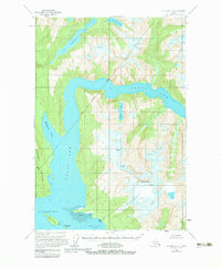
1960 Map of Sumdum D-4
USGS Topo · Published 1983About this map
Tracy Arm and Endicott Arm converge at Holkham Bay in this mid-century survey of the Southeast Alaska coast. The geography is defined by deep fjords and massive glacial formations, with the Sumdum Glacier descending from Mt Sumdum toward the water's edge. The presence of Indian Village (Aband) near the mouth of Powers Creek offers a specific point of interest for researchers of indigenous settlement patterns and historical coastal habitation within the Tongass National Forest.
Find a feature on this map
20 named features on this map. Tap any name to fly to it.
Don’t see what you’re looking for? This feature index may not catch every label — zoom into the map to look around manually.
Map Details
Editions of this 1960 Sumdum D-4 Map
4 editions found
Other maps of this area

1948 · Sumdum C-5
USGS Topo · 1:63,360

1948 · Sumdum D-5
USGS Topo · 1:63,360

1951 · Taku River A-4
USGS Topo · 1:63,360

1951 · Taku River A-5
USGS Topo · 1:63,360

1951 · Sumdum C-5
USGS Topo · 1:63,360

1952 · Sumdum
USGS Topo · 1:250,000

1953 · Taku River
USGS Topo · 1:250,000

1955 · Sumdum D-5
USGS Topo · 1:63,360

1960 · Taku River
USGS Topo · 1:250,000

1960 · Sumdum D-4
USGS Topo · 1:63,360