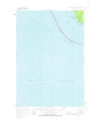
1961 Map of Mount Fairweather A-3
USGS Topo · Published 1973About this map
Glacier Bay National Monument borders the treacherous coastline where the Gulf of Alaska meets the Pacific Ocean in this 1961 field-annotated survey. The map focuses heavily on hydrographic data and maritime landmarks along the jagged eastern shore, featuring the Polka Peninsula and the prominent Point Villaluenga. An Indefinite Boundary runs through the open waters, separating the coastal monument waters from the open gulf. This nautical-heavy sheet includes detailed soundings and underwater contours compiled from previous coastal charts, providing a mid-century record of the sea floor and rocky outcrops like Graves Rocks and Polka Rk before the region’s further modern mapping and designation changes.
Find a feature on this map
9 named features on this map. Tap any name to fly to it.
Don’t see what you’re looking for? This feature index may not catch every label — zoom into the map to look around manually.
Map Details
Editions of this 1961 Mount Fairweather A-3 Map
2 editions found
Other maps of this area

1948 · Mount Fairweather A-2
USGS Topo · 1:63,360

1948 · Mount Fairweather B-2
USGS Topo · 1:63,360

1948 · Sitka D-8
USGS Topo · 1:63,360

1950 · Sitka D-8
USGS Topo · 1:63,360

1951 · Mt Fairweather
USGS Topo · 1:250,000

1951 · Sitka
USGS Topo · 1:250,000

1952 · Sitka
USGS Topo · 1:250,000
1961 · Mount Fairweather A-3
USGS Topo · 1:63,360
1961 · Mount Fairweather B-3
USGS Topo · 1:63,360
1961 · Mt Fairweather B-4
USGS Topo · 1:63,360