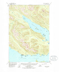
1955 Map of Sitka D-4
USGS Topo · Published 1985About this map
Chichagof Island is dominated by the deeply recessed waters of Freshwater Bay and Tenakee Inlet in this mid-century survey. The settlement of Tenakee (Tenakee Springs PO) serves as a primary point of interest on the southern shore, featuring a Light and nearby Campground. The map documents a coastal infrastructure reliant on the sea, with numerous Cabins, a Boathouse, and a Cannery situated along the rugged inlets.
Find a feature on this map
38 named features on this map. Tap any name to fly to it.
Don’t see what you’re looking for? This feature index may not catch every label — zoom into the map to look around manually.
Map Details
Editions of this 1955 Sitka D-4 Map
2 editions found

Other maps of this area

1948 · Juneau A-3
USGS Topo · 1:63,360

1948 · Juneau A-4
USGS Topo · 1:63,360

1948 · Sitka C-3
USGS Topo · 1:63,360

1948 · Sitka D-5
USGS Topo · 1:63,360

1948 · Sitka D-3
USGS Topo · 1:63,360

1948 · Sitka D-4
USGS Topo · 1:63,360

1950 · Juneau A-3
USGS Topo · 1:63,360

1951 · Juneau
USGS Topo · 1:250,000

1951 · Juneau A-5
USGS Topo · 1:63,360

1951 · Sitka C-5
USGS Topo · 1:63,360