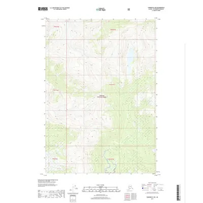
2017 Map of Sumdum B-4 NE
USGS Topo · Published 2017About this map
The vast, undeveloped terrain of the Tongass National Forest dominates this topographic study in the Petersburg Borough. The landscape is defined by extreme relief and steep drainage basins, centered on the winding course of the Chuck River as it flows through the western portion of the quadrangle. This area of Southeast Alaska is characterized by deep glacial valleys and high ridges that reach elevations exceeding 4,000 feet. The absence of roads or permanent structures reflects the protected wilderness status of the region. Detailed topographic contours reveal the complex alpine geography of the Coast Mountains, where drainage patterns are dictated by the sharp peaks and north-south trending valleys typical of the Alexander Archipelago's mainland interior.
Find a feature on this map
8 named features on this map. Tap any name to fly to it.
Don’t see what you’re looking for? This feature index may not catch every label — zoom into the map to look around manually.
Map Details
Editions of this 2017 Sumdum B-4 NE Map
This is the sole edition of this map. No revisions or reprints were ever made.
Other maps of this area

1943 · Sumdum B-4
USGS Topo · 1:63,360

1948 · Sumdum B-4
USGS Topo · 1:63,360

1952 · Sumdum
USGS Topo · 1:250,000

1961 · Sumdum C-3
USGS Topo · 1:63,360

1961 · Sumdum C-4
USGS Topo · 1:63,360

1961 · Sumdum B-3
USGS Topo · 1:63,360

1961 · Sumdum
USGS Topo · 1:250,000

1996 · Sumdum B-3
USGS Topo · 1:63,360

1996 · Sumdum B-4
USGS Topo · 1:63,360

2000 · Sumdum C-3
USGS Topo · 1:63,360