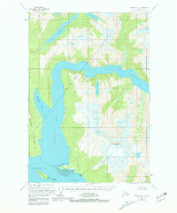
1955 Map of Sumdum D-5
USGS Topo · Published 1981About this map
Tracy Arm and Endicott Arm converge in this mid-century topographic study of the coastal fjords within the Tongass National Forest. The landscape is dominated by the massive Sumdum Glacier and the peak of Mt Sumdum, which tower over a network of glacial lakes including Icefall Lake and Sweetheart Lake. The shoreline along Holkham Bay reveals significant cultural history at Indian Villages (Aband), located near the mouth of Powers Creek. This area, managed within the City and Borough of Juneau, shows the stark relief of the Snettisham Peninsula and protected anchorages like Williams Cove and the waters surrounding Harbor Island. The map documents the intricate coastline before modern shifts, featuring numerous crevasses and tidal flats that define this maritime environment.
Find a feature on this map
20 named features on this map. Tap any name to fly to it.
Don’t see what you’re looking for? This feature index may not catch every label — zoom into the map to look around manually.
Map Details
Editions of this 1955 Sumdum D-5 Map
3 editions found

Other maps of this area

1948 · Sumdum D-6
USGS Topo · 1:63,360

1948 · Sumdum C-5
USGS Topo · 1:63,360

1948 · Sumdum C-6
USGS Topo · 1:63,360

1948 · Sumdum D-5
USGS Topo · 1:63,360

1951 · Taku River A-4
USGS Topo · 1:63,360

1951 · Taku River A-5
USGS Topo · 1:63,360

1951 · Taku River A-6
USGS Topo · 1:63,360

1951 · Sumdum C-5
USGS Topo · 1:63,360

1951 · Sumdum D-6
USGS Topo · 1:63,360

1951 · Sumdum C-6
USGS Topo · 1:63,360