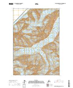
2017 Map of Mount Fairweather D-4 NW
USGS Topo · Published 2017About this map
Glacier Bay National Park dominates this high-altitude landscape where the international boundary between Alaska and Canada cuts across the extreme northwestern corner. The terrain is characterized by massive ice fields and active glacial movement, with the Margerie Glacier flowing into the upper reaches of the bay. In the southern portion of the sheet, the Johns Hopkins Glacier and Tyeen Glacier define the frozen geography of the Hoonah-Angoon Census Area. This survey represents a modern study of the shifting ice and extreme topography of the Fairweather Range. The map is devoid of human settlements or infrastructure, focusing instead on the dramatic natural features and township boundaries of the Public Land Survey System that extend across these remote coastal mountains.
Find a feature on this map
11 named features on this map. Tap any name to fly to it.
Don’t see what you’re looking for? This feature index may not catch every label — zoom into the map to look around manually.
Map Details
Editions of this 2017 Mount Fairweather D-4 NW Map
This is the sole edition of this map. No revisions or reprints were ever made.
Other maps of this area

1951 · Mt Fairweather
USGS Topo · 1:250,000

1952 · Skagway
USGS Topo · 1:250,000

1961 · Skagway A-7
USGS Topo · 1:63,360

1961 · Mount Fairweather D-4
USGS Topo · 1:63,360
1961 · Skagway A-6
USGS Topo · 1:63,360

1961 · Mount Fairweather D-5
USGS Topo · 1:63,360

1961 · Mt Fairweather
USGS Topo · 1:250,000

1961 · Skagway
USGS Topo · 1:250,000
2017 · Mount Fairweather D-4 SW
USGS Topo · 1:25,000
2017 · Mount Fairweather D-4 SE
USGS Topo · 1:25,000