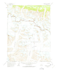
1954 Map of Skagway A-3
USGS Topo · Published 1975About this map
The Takhinsha Mountains and the massive glacial systems of Glacier Bay National Monument dominate this mid-century topographic survey. This frozen landscape is defined by the slow movement of the Casement Glacier and McBride Glacier, which flow toward the waters of Muir Inlet. The map illustrates a transitional period in Alaskan territory management, showing the National Monument Boundary as it intersects with the Haines Borough. At the northern edge, the Takhin River valley provides a break in the high-altitude terrain, which includes notable summits such as Mount Krause, Sitth-gha-ee Peak, and Coleman Peak. To the south, prominent landforms like McConnell Ridge and Van Horn Ridge mark the complex geology surrounding the ice fields.
Find a feature on this map
19 named features on this map. Tap any name to fly to it.
Don’t see what you’re looking for? This feature index may not catch every label — zoom into the map to look around manually.
Map Details
Editions of this 1954 Skagway A-3 Map
3 editions found
Other maps of this area

1948 · Mount Fairweather D-1
USGS Topo · 1:63,360

1949 · Juneau D-6
USGS Topo · 1:63,360

1951 · Juneau
USGS Topo · 1:250,000

1951 · Mt Fairweather
USGS Topo · 1:250,000

1952 · Skagway
USGS Topo · 1:250,000

1954 · Mount Fairweather D-1
USGS Topo · 1:63,360

1954 · Skagway B-2
USGS Topo · 1:63,360

1954 · Skagway A-3
USGS Topo · 1:63,360

1954 · Skagway A-2
USGS Topo · 1:63,360

1954 · Skagway B-3
USGS Topo · 1:63,360