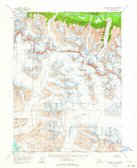
1954 Map of Skagway A-3
USGS Topo · Published 1964About this map
Glacier Bay National Monument dominates this mid-century topographic record, capturing a landscape defined by massive ice flows and high alpine ridges in Southeast Alaska. The map traces the vast reaches of the Mc Bride Glacier and Casement Glacier, illustrating the complex network of crevasses and glacial runoff that feeds into Muir Inlet. To the north, the Takhinsha Mountains form a formidable barrier, with the National Monument Boundary cutting through their high peaks. The presence of named landmarks such as Sitth-gha-ee Peak and Coleman Peak provides specific points of reference for navigating this ice-bound wilderness. Along the northern edge, the Takhin River valley creates a distinct corridor of low-lying terrain, contrasting with the sheer elevations of Red Mountain and McConnell Ridge to the south.
Find a feature on this map
17 named features on this map. Tap any name to fly to it.
Don’t see what you’re looking for? This feature index may not catch every label — zoom into the map to look around manually.
Map Details
Editions of this 1954 Skagway A-3 Map
3 editions found
Other maps of this area

1948 · Mount Fairweather D-1
USGS Topo · 1:63,360

1949 · Juneau D-6
USGS Topo · 1:63,360

1951 · Juneau
USGS Topo · 1:250,000

1951 · Mt Fairweather
USGS Topo · 1:250,000

1952 · Skagway
USGS Topo · 1:250,000

1954 · Mount Fairweather D-1
USGS Topo · 1:63,360

1954 · Skagway B-2
USGS Topo · 1:63,360

1954 · Skagway A-3
USGS Topo · 1:63,360

1954 · Skagway A-2
USGS Topo · 1:63,360

1954 · Skagway B-3
USGS Topo · 1:63,360