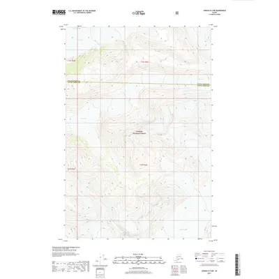
2017 Map of Juneau D-2 NW
USGS Topo · Published 2017About this map
Tongass National Forest dominates this Alaskan landscape, where the high-altitude terrain is defined by massive glacial formations and deep topographic relief. The map center is largely occupied by the northern reaches of the forest, while the frozen expanse of Field Glacier stretches across the northern border, and Bucher Glacier marks the southeastern corner. This survey documents the remote boundary line between Haines Borough and Juneau Borough, which cuts across the high ridges. The map illustrates a transitional environment of permanent ice and rugged forest land, offering a detailed look at the drainage patterns and elevation contours that define this portion of the Panhandle before the impact of 21st-century glacial recession.
Find a feature on this map
4 named features on this map. Tap any name to fly to it.
Don’t see what you’re looking for? This feature index may not catch every label — zoom into the map to look around manually.
Map Details
Editions of this 2017 Juneau D-2 NW Map
This is the sole edition of this map. No revisions or reprints were ever made.
Other maps of this area

1948 · Juneau D-3
USGS Topo · 1:63,360

1949 · Atlin
USGS Topo · 1:250,000

1949 · Juneau D-3
USGS Topo · 1:63,360

1951 · Juneau
USGS Topo · 1:250,000

1951 · Atlin
USGS Topo · 1:250,000

1953 · Juneau D-3
USGS Topo · 1:63,360

1960 · Juneau D-2
USGS Topo · 1:63,360

1960 · Atlin A-8
USGS Topo · 1:63,360
1960 · Atlin A-7
USGS Topo · 1:63,360

1960 · Atlin
USGS Topo · 1:250,000