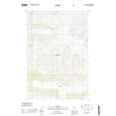
2017 Map of Juneau D-2 SW
USGS Topo · Published 2017About this map
The Tongass National Forest defines this high-elevation landscape within the Alaskan panhandle, dominated by massive ice fields and the steep relief of the Coast Mountains. This survey captures the physical geography of the region just north of Juneau, focusing on the glacial dynamics of Antler Glacier and Bucher Glacier. These frozen masses feed into the glacial runoff systems of the Antler River and Gilkey River, which carve through the terrain as they flow toward the coast. The absence of roads or permanent settlements highlights the wilderness character of this area in the early twenty-first century, where the landscape is shaped primarily by ice and water. For those studying the environmental changes in Southeast Alaska, the precise contour lines and glacial boundaries provided by the U.S. Geological Survey offer a baseline for observing the recession and flow of these coastal ice systems.
Find a feature on this map
12 named features on this map. Tap any name to fly to it.
Don’t see what you’re looking for? This feature index may not catch every label — zoom into the map to look around manually.
Map Details
Editions of this 2017 Juneau D-2 SW Map
This is the sole edition of this map. No revisions or reprints were ever made.
Other maps of this area

1948 · Juneau D-3
USGS Topo · 1:63,360

1949 · Juneau D-3
USGS Topo · 1:63,360

1951 · Juneau
USGS Topo · 1:250,000

1951 · Juneau C-3
USGS Topo · 1:63,360

1952 · Juneau C-3
USGS Topo · 1:63,360

1953 · Juneau D-3
USGS Topo · 1:63,360

1960 · Juneau C-2
USGS Topo · 1:63,360

1960 · Juneau D-2
USGS Topo · 1:63,360

1962 · Juneau
USGS Topo · 1:250,000
1996 · Juneau C-3
USGS Topo · 1:63,360