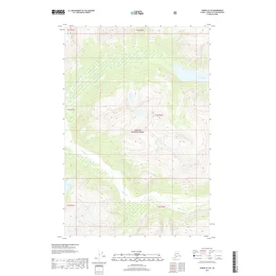
2017 Map of Juneau D-3 SE
USGS Topo · Published 2017About this map
Antler Glacier dominates the northeastern corner of this coastal Alaskan landscape, situated within the protected boundaries of the Tongass National Forest. The glacial melt feeds into the Antler River, which winds through the northern valley before the topography shifts south toward the course of the Gilkey River. This 2017 survey illustrates the complex relationship between ice, water, and elevation in the region north of Juneau. The presence of Antler Lake in the southwest quadrant provides a distinct hydrological reference point amidst the steep, undeveloped terrain of the Alexander Archipelago. The map serves as a record of the drainage patterns and ice extent in a period of active environmental change, documenting the exact contours of the glacial terminus and the braided river systems that define this wilderness.
Find a feature on this map
12 named features on this map. Tap any name to fly to it.
Don’t see what you’re looking for? This feature index may not catch every label — zoom into the map to look around manually.
Map Details
Editions of this 2017 Juneau D-3 SE Map
This is the sole edition of this map. No revisions or reprints were ever made.
Other maps of this area

1948 · Juneau D-3
USGS Topo · 1:63,360

1949 · Juneau D-3
USGS Topo · 1:63,360

1951 · Juneau
USGS Topo · 1:250,000

1951 · Juneau C-3
USGS Topo · 1:63,360

1952 · Juneau C-3
USGS Topo · 1:63,360

1953 · Juneau D-3
USGS Topo · 1:63,360

1960 · Juneau C-2
USGS Topo · 1:63,360

1960 · Juneau D-2
USGS Topo · 1:63,360

1962 · Juneau
USGS Topo · 1:250,000
1986 · Juneau C-3 NW
USGS Topo · 1:25,000