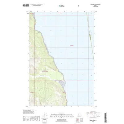
2017 Map of Juneau D-4 SW
USGS Topo · Published 2017About this map
Tongass National Forest dominates the western shoreline of the Lynn Canal, where the rugged coast of Southeast Alaska meets the deep waters of the Inside Passage. The steep, heavily contoured terrain is bisected by the Endicott River, which flows eastward from the mountainous interior to discharge into the canal. This 2017 survey delineates the administrative boundary between the Juneau Borough and Haines Borough, which runs nearly north-to-south through the open water of the canal. The map provides a clear record of the untouched wilderness within the national forest system, showing the intricate relationship between the glaciated topography and the marine environment of the Alexander Archipelago.
Find a feature on this map
4 named features on this map. Tap any name to fly to it.
Don’t see what you’re looking for? This feature index may not catch every label — zoom into the map to look around manually.
Map Details
Editions of this 2017 Juneau D-4 SW Map
This is the sole edition of this map. No revisions or reprints were ever made.
Other maps of this area

1948 · Juneau C-5
USGS Topo · 1:63,360

1948 · Juneau C-4
USGS Topo · 1:63,360

1949 · Juneau D-5
USGS Topo · 1:63,360

1949 · Juneau D-4
USGS Topo · 1:63,360

1949 · Juneau C-4
USGS Topo · 1:63,360

1951 · Juneau
USGS Topo · 1:250,000

1951 · Juneau D-4
USGS Topo · 1:63,360

1962 · Juneau
USGS Topo · 1:250,000
1996 · Juneau C-4
USGS Topo · 1:63,360
1996 · Juneau D-5
USGS Topo · 1:63,360