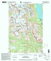
1996 Map of Juneau D-5
USGS Topo · Published 2000About this map
The Chilkat Range dominates this landscape where the Endicott River Wilderness meets the protected reaches of the Tongass National Forest. Compiled from mid-century topography and late-20th-century imagery, the map details a region of massive icefields and coastal waters within the Haines Borough. High summits like Mount Young overlook the Lynn Canal, while the southern portion of the sheet is defined by the Endicott River as it cuts toward the coast. Along the eastern shoreline, the presence of a Microwave Station and Sullivan Island mark the transition from the glaciated interior of Glacier Bay National Park and Preserve to the vital maritime corridors of Southeast Alaska. The intricate contour work illustrates the complex glacial geography and drainage patterns essential for understanding the environmental history of this wilderness interface.
Find a feature on this map
11 named features on this map. Tap any name to fly to it.
Don’t see what you’re looking for? This feature index may not catch every label — zoom into the map to look around manually.
Map Details
Editions of this 1996 Juneau D-5 Map
This is the sole edition of this map. No revisions or reprints were ever made.
Other maps of this area

1948 · Juneau C-5
USGS Topo · 1:63,360

1948 · Juneau C-4
USGS Topo · 1:63,360

1948 · Juneau C-6
USGS Topo · 1:63,360

1948 · Skagway A-1
USGS Topo · 1:63,360

1949 · Juneau D-6
USGS Topo · 1:63,360

1949 · Juneau D-5
USGS Topo · 1:63,360

1949 · Juneau D-4
USGS Topo · 1:63,360

1949 · Juneau C-4
USGS Topo · 1:63,360

1950 · Juneau C-6
USGS Topo · 1:63,360

1951 · Juneau
USGS Topo · 1:250,000