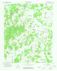
1955 Map of Juno
USGS Topo · Published 1981About this map
Juno and the surrounding rural landscapes of Henderson and Madison counties are defined by the intricate drainages of the Middle Fork Forked Deer River and its numerous tributaries. This survey, based on aerial photography from the late 1940s with revisions through 1980, captures a network of small agricultural communities such as Blue Goose, Poplar Springs, and Crucifer. The placement of Wards Grove Ch, Independence Ch, and Union Grove Ch alongside scattered schoolhouses like Unity Sch and Claybrook Sch reveals a settlement pattern centered on local congregation and education. The terrain is deeply carved by watercourses like Gurley Creek and McHaney Branch, which dictated the winding paths of the early road system. This map is particularly valuable for family historians, as it identifies small burial sites including Hamlet Cem and Anderson Cem that might otherwise be overlooked in modern records.
Find a feature on this map
33 named features on this map. Tap any name to fly to it.
Don’t see what you’re looking for? This feature index may not catch every label — zoom into the map to look around manually.
Map Details
Editions of this 1955 Juno Map
2 editions found
Other maps of this area

1936 · Clarksburg
USGS Topo · 1:24,000

1936 · Lexington
USGS Topo · 1:24,000

1936 · Life
USGS Topo · 1:24,000

1950 · Life
USGS Topo · 1:24,000

1950 · Lexington
USGS Topo · 1:24,000

1950 · Clarksburg
USGS Topo · 1:24,000

1953 · Claybrook
USGS Topo · 1:24,000

1953 · Beech Bluff
USGS Topo · 1:24,000

1955 · Luray
USGS Topo · 1:24,000

1955 · Juno
USGS Topo · 1:24,000