
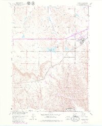
1951 Map of Kadoka
USGS Topo · Published 1952About this map
Kadoka serves as a central hub on this mid-century prairie landscape, situated near the intersection of several critical transport routes. The town is flanked by the Chicago Milwaukee St Paul and Pacific railroad and the waters of Kadoka Lake, while Kadoka Junction marks the convergence of local transit paths. This 1951 survey reveals a landscape balanced between established settlement and the open geography of the Great Plains, stretching south toward the White River.
Find a feature on this map
14 named features on this map. Tap any name to fly to it.
Don’t see what you’re looking for? This feature index may not catch every label — zoom into the map to look around manually.
Map Details
Editions of this 1951 Kadoka Map
2 editions found
Other maps of this area

1950 · Weta
USGS Topo · 1:24,000

1951 · Wanblee NW
USGS Topo · 1:24,000

1951 · Pass Creek NW
USGS Topo · 1:24,000

1951 · Belvidere SW
USGS Topo · 1:24,000

1951 · Wanblee NE
USGS Topo · 1:24,000

1953 · Philip Junction
USGS Topo · 1:24,000

1954 · Belvidere NW
USGS Topo · 1:24,000

1954 · Kadoka NE
USGS Topo · 1:24,000

1955 · Martin
USGS Topo · 1:250,000

1958 · Martin
USGS Topo · 1:250,000