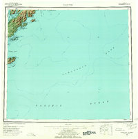
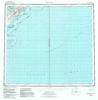
1952 Map of Kaguyak
USGS Topo · Published 1962About this map
Kaguyak sits on the southeastern coast of Kodiak Island, appearing here as a vital coastal outpost before the 1964 earthquake and tsunami fundamentally altered the area's geography. This survey provides a specialized look at the intricate coastline of the Hepburn Peninsula and the many offshore landmarks, including Twoheaded Island and the Trinity Islands to the south. The hydrography, compiled from earlier charts, illustrates the relationship between the island's rocky inlets like Boot Inlet and the vast seafloor topography of the Albatross Bank in the Pacific Ocean. Onshore, the terrain is defined by dramatic coastal features like Shag Bluff and Knoll Pt, while inland, a solitary Cabin remains one of the few identified structures, reflecting the sparse, maritime-dependent life of this coastal region during the early 1950s.
Find a feature on this map
28 named features on this map. Tap any name to fly to it.
Don’t see what you’re looking for? This feature index may not catch every label — zoom into the map to look around manually.
Map Details
Editions of this 1952 Kaguyak Map
6 editions found
Other maps of this area

1949 · Kodiak A-3
USGS Topo · 1:63,360

1950 · Kodiak A-3
USGS Topo · 1:63,360

1951 · Kaguyak
USGS Topo · 1:250,000

1951 · Trinity Islands
USGS Topo · 1:250,000

1951 · Karluk
USGS Topo · 1:250,000

1952 · Kodiak
USGS Topo · 1:250,000

1952 · Kaguyak
USGS Topo · 1:250,000

1952 · Karluk
USGS Topo · 1:250,000

1952 · Kaguyak D-5
USGS Topo · 1:63,360

1952 · Trinity Islands D-1
USGS Topo · 1:63,360