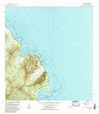
1983 Map of Kahana
USGS Topo · Published 1983About this map
Ancient Hawaiian fishponds and steep volcanic ridges define this coastal stretch of windward Oahu in the early 1980s. The shoreline is punctuated by Huila Pond and the large Molii Pond near Kualoa Point, showing the preservation of traditional aquaculture alongside modern designations like Kualoa Regional Park. Inland, the terrain rises sharply to the peaks of Puu Kanehoalani and Puu Manamana, carved by the Kahana Stream and Punaluu Stream.
Find a feature on this map
36 named features on this map. Tap any name to fly to it.
Don’t see what you’re looking for? This feature index may not catch every label — zoom into the map to look around manually.
Map Details
Editions of this 1983 Kahana Map
2 editions found
Other maps of this area

1952 · Mokapu
USGS Topo · 1:24,000

1953 · Hauula
USGS Topo · 1:24,000

1954 · Oahu
USGS Topo · 1:250,000

1954 · Kahuku
USGS Topo · 1:24,000

1954 · Kahana
USGS Topo · 1:24,000

1954 · Kaneohe
USGS Topo · 1:24,000

1954 · Waipahu
USGS Topo · 1:24,000

1959 · Mokapu
USGS Topo · 1:24,000

1959 · Kaneohe
USGS Topo · 1:24,000

1959 · Waipahu
USGS Topo · 1:24,000