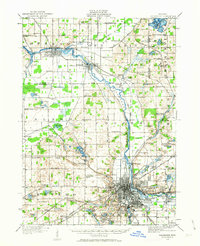
1916 Map of Kalamazoo
USGS Topo · Published 1963About this map
Kalamazoo stands as a dense urban center at the crossroads of several major rail lines, including the Michigan Central RR and the Grand Rapids and Indiana RR. To the north, the industrial settlements of Parchment, Plainwell, and Otsego follow the winding course of the Kalamazoo River, which served as a vital corridor for commerce and power. This 1916 survey reveals a landscape transitioning from rural agrarian townships to a more integrated industrial region, evidenced by the high concentration of neighborhood institutions such as the Grand Prairie School and the sprawling grounds of the State Hospital. Beyond the city limits, the terrain is dotted with small agricultural hubs and landmarks like Nazareth Academy and the settlement of Oshtemo. The map meticulously details the network of local roads, such as the Base Line and Territorial Road, which connected the surrounding Plains to the rail corridors that defined early twentieth-century Michigan geography.
Find a feature on this map
96 named features on this map. Tap any name to fly to it.
Don’t see what you’re looking for? This feature index may not catch every label — zoom into the map to look around manually.
Map Details
Editions of this 1916 Kalamazoo Map
3 editions found
Other maps of this area

1916 · Kalamazoo
USGS Topo · 1:62,500

1918 · Kalamazoo
USGS Topo · 1:62,500

1918 · Galesburg
USGS Topo · 1:62,500

1918 · Leonidas
USGS Topo · 1:62,500

1922 · Schoolcraft
USGS Topo · 1:62,500

1943 · Kalamazoo
USGS Topo · 1:62,500

1943 · Schoolcraft
USGS Topo · 1:62,500

1944 · Leonidas
USGS Topo · 1:62,500

1944 · Galesburg
USGS Topo · 1:62,500

1944 · Marcellus
USGS Topo · 1:62,500