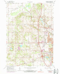
1967 Map of Kalamazoo SW
USGS Topo · Published 1974About this map
Kalamazoo expands westward into the surrounding townships during the mid-1960s, a period marked by suburban growth and the integration of local institutions into the landscape. The southern reaches of this survey are defined by the State Hospital grounds and the waters of Asylum Lake, while the nascent community of Westwood shows residential density near Croyden Ave and Olney St. Further west, the terrain remains more agricultural and open, punctuated by rural centers like Oshtemo and Doughertys Corners.
Find a feature on this map
64 named features on this map. Tap any name to fly to it.
Don’t see what you’re looking for? This feature index may not catch every label — zoom into the map to look around manually.
Map Details
Editions of this 1967 Kalamazoo SW Map
4 editions found
Other maps of this area

1916 · Kalamazoo
USGS Topo · 1:62,500

1918 · Kalamazoo
USGS Topo · 1:62,500

1922 · Schoolcraft
USGS Topo · 1:62,500

1943 · Kalamazoo
USGS Topo · 1:62,500

1943 · Schoolcraft
USGS Topo · 1:62,500

1944 · Marcellus
USGS Topo · 1:62,500

1946 · Marcellus
USGS Topo · 1:62,500

1946 · Gobles
USGS Topo · 1:62,500

1948 · Gobles
USGS Topo · 1:62,500

1949 · Gobles
USGS Topo · 1:62,500