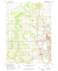
1967 Map of Kalamazoo SW
USGS Topo · Published 1974About this map
The sprawling grounds of the State Hospital and the suburban expansion of Kalamazoo define this mid-century portrait of southwestern Michigan. West of the city, the landscape is a mix of developing neighborhoods like Westwood and rural crossroads such as Doughertys Corners. The Penn Central rail line cuts across the terrain, passing through the township of Alamo and near the Kalamazoo Speedway. The map reveals a high density of community institutions, from the Indian Prairie Sch and Chime Street Sch to numerous local congregations like the Northwest Oshtemo Ch. Significant genealogy data is preserved here via several burial grounds, including Alamo Cem, Grand Prairie Cem, and the Genesee Prairie Cem. Farther west, the terrain transitions into a series of kettle lakes and depressions, including Bonnie Castle Lake, Dustin Lake, and Mud Lakes, often flanked by local Gravel Pits.
Find a feature on this map
68 named features on this map. Tap any name to fly to it.
Don’t see what you’re looking for? This feature index may not catch every label — zoom into the map to look around manually.
Map Details
Editions of this 1967 Kalamazoo SW Map
4 editions found
Other maps of this area

1916 · Kalamazoo
USGS Topo · 1:62,500

1918 · Kalamazoo
USGS Topo · 1:62,500

1922 · Schoolcraft
USGS Topo · 1:62,500

1943 · Kalamazoo
USGS Topo · 1:62,500

1943 · Schoolcraft
USGS Topo · 1:62,500

1944 · Marcellus
USGS Topo · 1:62,500

1946 · Marcellus
USGS Topo · 1:62,500

1946 · Gobles
USGS Topo · 1:62,500

1948 · Gobles
USGS Topo · 1:62,500

1949 · Gobles
USGS Topo · 1:62,500