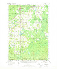
1956 Map of Kalkaska
USGS Topo · Published 1973About this map
The village of Kalkaska serves as the primary hub of this northern Michigan landscape, situated at the junction of the Pennsylvania Railroad and the Boardman River. The mid-century geography reveals a dense network of rural infrastructure, including numerous schoolhouses like Tyler Sch and the Maple Grove Sch, which was already noted as abandoned by the mid-1950s. The terrain is characterized by its glacial hydrology, featuring complex clusters of water bodies such as Twenty-eight Lakes and the headwaters of the Little Rapid River.
Find a feature on this map
105 named features on this map. Tap any name to fly to it.
Don’t see what you’re looking for? This feature index may not catch every label — zoom into the map to look around manually.
Map Details
Editions of this 1956 Kalkaska Map
4 editions found
Other maps of this area

1949 · Black Creek
USGS Topo · 1:24,000

1949 · Fletcher
USGS Topo · 1:62,500

1950 · Fletcher
USGS Topo · 1:24,000

1954 · Traverse City
USGS Topo · 1:250,000

1956 · Alba
USGS Topo · 1:62,500

1956 · Mancelona
USGS Topo · 1:62,500

1956 · Kalkaska
USGS Topo · 1:62,500

1956 · Fife Lake
USGS Topo · 1:62,500

1956 · Houghton Lake
USGS Topo · 1:62,500

1956 · Cadillac North
USGS Topo · 1:62,500