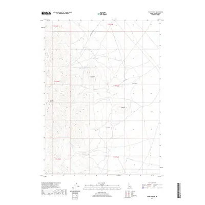
2020 Map of Kane Canyon
USGS Topo · Published 2020About this map
The Jim Sage Mountains dominate the western edge of this Cassia County landscape, where the high desert terrain transitions into prominent peaks like Red Rock Mtn and Sheep Mtn. This modern survey highlights a remote rangeland defined by its critical water sources, including Red Rock Spring and Kane Spring. The presence of Ward Sheep Ranch Rd reflects the long-standing livestock heritage of southern Idaho, providing access through the high country toward Parks Cr. Between the heights of Cedar Knoll and the drainage of Cottonwood Cr, the map traces the natural corridor of Kane Canyon. The sparse road network, primarily consisting of Kane Spring Rd, emphasizes the isolation of these public lands, which remain largely focused on traditional grazing and watershed management.
Find a feature on this map
17 named features on this map. Tap any name to fly to it.
Don’t see what you’re looking for? This feature index may not catch every label — zoom into the map to look around manually.
Map Details
Editions of this 2020 Kane Canyon Map
This is the sole edition of this map. No revisions or reprints were ever made.
Other maps of this area

1954 · Pocatello
USGS Topo · 1:250,000

1958 · Pocatello
USGS Topo · 1:250,000

1968 · Malta
USGS Topo · 1:24,000

1968 · Jim Sage Canyon
USGS Topo · 1:24,000

1968 · Elba
USGS Topo · 1:24,000

1968 · Kane Canyon
USGS Topo · 1:24,000

1968 · Nibbs Creek
USGS Topo · 1:24,000

1968 · Naf
USGS Topo · 1:24,000

1968 · Chokecherry Canyon
USGS Topo · 1:24,000
1968 · Connor Ridge
USGS Topo · 1:24,000