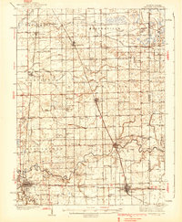
1924 Map of Kankakee
USGS Topo · Published 1924About this map
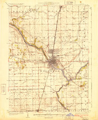
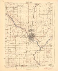
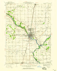
The Kankakee River winds through this central Illinois landscape, serving as a primary corridor for development between Kankakee, Bourbonnais, and Bradley. This 1922 survey documents a region defined by its diverse transportation network, where the Egyptian Trail and Illinois Electric Interurban intersect with the heavy rail lines of the Illinois Central and New York Central. The map reveals a dense distribution of rural education centers, including uniquely named sites like Flickerville School, Altdorf School, and Beecherown School, alongside major institutions such as the East Illinois Hospital.
Find a feature on this map
99 named features on this map. Tap any name to fly to it.
Don’t see what you’re looking for? This feature index may not catch every label — zoom into the map to look around manually.
Map Details
Editions of this 1924 Kankakee Map
2 editions found
Other maps of this area

1892 · Wilmington
USGS Topo · 1:62,500

1918 · Wilmington
USGS Topo · 1:62,500

1922 · Momence
USGS Topo · 1:62,500
1922 · Kankakee
USGS Topo · 1:62,500

1923 · Herscher
USGS Topo · 1:62,500

1924 · Momence
USGS Topo · 1:62,500

1925 · Herscher
USGS Topo · 1:62,500
1935 · Watseka
USGS Topo · 1:48,000
1939 · Watseka
USGS Topo · 1:62,500
1944 · Piper City
USGS Topo · 1:48,000