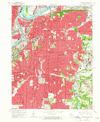
1964 Map of Kansas City
USGS Topo · Published 1965About this map
Kansas City is defined by its complex industrial and transport network, where the Missouri River and Kansas River converge amidst a dense web of rail lines. This 1964 revision captures the city’s mid-century skyline and infrastructure, from the Municipal Airport on the river bend to the historic Union Station. The map illustrates a landscape of established neighborhoods served by numerous parochial and public institutions, such as St Vincents Academy and Rockhurst College. The southern reach is dominated by expansive greenspaces and cultural landmarks like Swope Park and the Nelson Art Gallery. On the city's periphery, smaller communities like Westwood and Mission Hills are established along the winding course of Brush Creek, while the eastern industrial corridor follows the Blue River valley near the Leeds settlement.
Find a feature on this map
122 named features on this map. Tap any name to fly to it.
Don’t see what you’re looking for? This feature index may not catch every label — zoom into the map to look around manually.
Map Details
Editions of this 1964 Kansas City Map
3 editions found
Other maps of this area

1887 · Harrisonville
USGS Topo · 1:125,000

1887 · Olathe
USGS Topo · 1:125,000

1890 · Kansas City
USGS Topo · 1:125,000

1892 · Harrisonville
USGS Topo · 1:125,000

1893 · Olathe
USGS Topo · 1:125,000

1894 · Kansas City
USGS Topo · 1:125,000

1894 · Harrisonville
USGS Topo · 1:125,000

1894 · Independence
USGS Topo · 1:125,000

1934 · Independence
USGS Topo · 1:24,000

1934 · Grandview
USGS Topo · 1:24,000