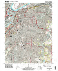
1991 Map of Kansas City
USGS Topo · Published 1995About this map
The Missouri River and Kansas River confluence serves as the anchor for this dense urban landscape, where the Missouri-Kansas state line divides the metropolitan center. Transport infrastructure dominates the riverfronts, defined by the Lewis and Clark Viaduct, the Broadway Bridge (Toll), and the ASB Bridge providing critical connections between Kansas City and northern points like Harlem. The map captures the significant role of the Downtown Airport tucked into a bend of the Missouri, while the industrial character of Leeds sits to the east along the Blue River. Extensive green spaces and civic institutions are woven into the residential fabric, including the expansive Swope Park with The Lagoon and Amphitheater. Institutional landmarks like the Univ of Kansas Medical Center and Rockhurst College appear alongside numerous memorial grounds such as Elmwood Cemetery and Forest Hill Cemetery.
Find a feature on this map
65 named features on this map. Tap any name to fly to it.
Don’t see what you’re looking for? This feature index may not catch every label — zoom into the map to look around manually.
Map Details
Editions of this 1991 Kansas City Map
2 editions found
Other maps of this area

1887 · Harrisonville
USGS Topo · 1:125,000

1887 · Olathe
USGS Topo · 1:125,000

1890 · Kansas City
USGS Topo · 1:125,000

1892 · Harrisonville
USGS Topo · 1:125,000

1893 · Olathe
USGS Topo · 1:125,000

1894 · Kansas City
USGS Topo · 1:125,000

1894 · Harrisonville
USGS Topo · 1:125,000

1894 · Independence
USGS Topo · 1:125,000

1934 · Independence
USGS Topo · 1:24,000

1934 · Grandview
USGS Topo · 1:24,000