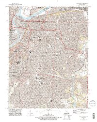
1991 Map of Kansas City
USGS Topo · Published 1995About this map
The Missouri River and Kansas River define the northern and western reaches of this urban landscape, where complex river-and-rail infrastructure meets established neighborhoods. Major river crossings like the ASB Bridge and the Paseo Bridge connect Kansas City to northern settlements like Harlem, while the Kansas City Southern Ry underscores the city's role as a transportation hub. Large greenspaces and historic grounds are prominent throughout the area, including the sprawling Swope Park and numerous significant burial sites such as Union Cemetery and Elmwood Cemetery. These sites, along with the Forest Hill Cemetery, provide valuable anchor points for genealogical research within the city's core. Educational and industrial zones further shape the geography, with Rockhurst College and the Univ of Missouri at Kansas City serving as landmarks alongside the industrial district of Leeds and the active runways of the Downtown Airport.
Find a feature on this map
59 named features on this map. Tap any name to fly to it.
Don’t see what you’re looking for? This feature index may not catch every label — zoom into the map to look around manually.
Map Details
Editions of this 1991 Kansas City Map
2 editions found
Other maps of this area

1887 · Harrisonville
USGS Topo · 1:125,000

1887 · Olathe
USGS Topo · 1:125,000

1890 · Kansas City
USGS Topo · 1:125,000

1892 · Harrisonville
USGS Topo · 1:125,000

1893 · Olathe
USGS Topo · 1:125,000

1894 · Kansas City
USGS Topo · 1:125,000

1894 · Harrisonville
USGS Topo · 1:125,000

1894 · Independence
USGS Topo · 1:125,000

1934 · Independence
USGS Topo · 1:24,000

1934 · Grandview
USGS Topo · 1:24,000