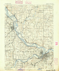
1890 Map of Kansas City
USGS Topo · Published 1890About this map
The Missouri River forms the spine of this late-nineteenth-century study, illustrating the complex riverine geography of the Kansas and Missouri borderlands. Before twentieth-century channelization, the river meandered through a wide floodplain, leaving behind features like Kickapoo Island, Diamond Island, and the Old Channel of Platte River. The map captures a pivotal era of rail expansion, where numerous lines like the Missouri Pacific Railroad and the Chicago Rock Island and Pacific Railroad converge on the developing urban centers of Argentine, Rosedale, and Leavenworth. Smaller settlements such as White Church, Camden Point, and Waldron dot the interior, connected by early wagon roads that follow the ridges between drainages like Todd Creek and Shoal Creek. This era reveals a landscape transition from agrarian homesteads to a high-density industrial corridor fueled by river and rail traffic.
Find a feature on this map
133 named features on this map. Tap any name to fly to it.
Don’t see what you’re looking for? This feature index may not catch every label — zoom into the map to look around manually.
Map Details
Editions of this 1890 Kansas City Map
2 editions found
Other maps of this area

1885 · Atchison
USGS Topo · 1:125,000

1885 · Lawrence
USGS Topo · 1:125,000

1886 · Oskaloosa
USGS Topo · 1:125,000

1887 · Harrisonville
USGS Topo · 1:125,000

1887 · Olathe
USGS Topo · 1:125,000

1888 · Oskaloosa
USGS Topo · 1:125,000

1888 · Atchison
USGS Topo · 1:125,000

1889 · Lawrence
USGS Topo · 1:125,000

1890 · Kansas City
USGS Topo · 1:125,000

1892 · Harrisonville
USGS Topo · 1:125,000