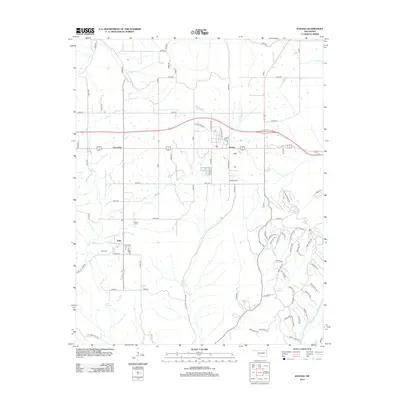
2012 Map of Kansas
USGS Topo · Published 2012About this map
Kansas serves as the primary hub of this eastern Oklahoma landscape, where the local street grid including Main St and Cherokee St meets a web of rural routes. The map records a transition from the structured residential blocks of Kansas to the more dispersed communities of Oaks and Twin Oaks. Water is a defining element of the geography, with the Illinois River flowing in the southeast and numerous named springs and creeks, such as Black Fox Springs and Spring Cr, providing the drainage for this undulating terrain.
Find a feature on this map
89 named features on this map. Tap any name to fly to it.
Don’t see what you’re looking for? This feature index may not catch every label — zoom into the map to look around manually.
Map Details
Editions of this 2012 Kansas Map
This is the sole edition of this map. No revisions or reprints were ever made.
Other maps of this area

1899 · Siloam Springs
USGS Topo · 1:125,000

1903 · Siloam Springs
USGS Topo · 1:125,000

1904 · Siloam Springs
USGS Topo · 1:125,000

1954 · Tulsa
USGS Topo · 1:250,000

1958 · Tulsa
USGS Topo · 1:250,000

1963 · Tulsa
USGS Topo · 1:250,000

1971 · Kenwood
USGS Topo · 1:24,000

1971 · Jay SE
USGS Topo · 1:24,000
1971 · Colcord
USGS Topo · 1:24,000
1972 · Chance
USGS Topo · 1:24,000