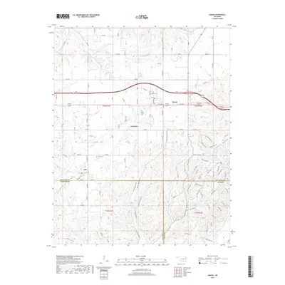
2019 Map of Kansas
USGS Topo · Published 2019About this map
Kansas anchors this northeastern Oklahoma survey, situated at the crossroads of major regional thoroughfares where Tulsa Ave and Main St form the town's core. The landscape transitions from the developed streets of the town center to the intricate drainages of Black Fox Hollow and Fivemile Hollow. Smaller settlements such as Twin Oaks and Oaks are documented along with several community burial grounds, including Kansas Cem, Long Prairie Cem, and Russell Cem, which provide essential points of reference for local family history. Water is a defining element of the southern terrain, where the Illinois River flows near Deer Lake and Clear Cr Lake. The map details a dense network of rural roads like E 540 Rd and n4600, tracing the residential and agricultural expansion into the surrounding timbered hollows and creek valleys of Saline Cr and Spring Cr.
Find a feature on this map
112 named features on this map. Tap any name to fly to it.
Don’t see what you’re looking for? This feature index may not catch every label — zoom into the map to look around manually.
Map Details
Editions of this 2019 Kansas Map
This is the sole edition of this map. No revisions or reprints were ever made.
Other maps of this area

1899 · Siloam Springs
USGS Topo · 1:125,000

1903 · Siloam Springs
USGS Topo · 1:125,000

1904 · Siloam Springs
USGS Topo · 1:125,000

1954 · Tulsa
USGS Topo · 1:250,000

1958 · Tulsa
USGS Topo · 1:250,000

1963 · Tulsa
USGS Topo · 1:250,000

1971 · Kenwood
USGS Topo · 1:24,000

1971 · Jay SE
USGS Topo · 1:24,000
1971 · Colcord
USGS Topo · 1:24,000
1972 · Chance
USGS Topo · 1:24,000