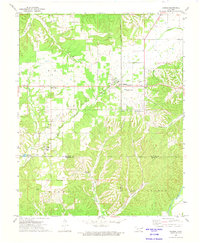
1972 Map of Kansas
USGS Topo · Published 1974About this map
The Illinois River flows through the southeastern corner of this Ozark foothills landscape, a region defined by the convergence of Delaware, Cherokee, and Adair counties in the early 1970s. The settlement of Kansas serves as a local hub, while smaller communities like Twin Oaks and Oaks are established along the valley floors. The map reveals a rural social infrastructure centered on small country churches, including Mountain View Ch and the Walnut Grove Mission. Significant water features like Spring Creek and Saline Creek cut through the terrain, leading toward several distinct hollows such as Fivemile Hollow and Winset Hollow. Genealogists may find value in the location of Russell Cem and Oaks Cem, while the presence of an abandoned fish hatchery near Oaks and a Quarry near Cloud Creek point to shifting local land use and industry.
Find a feature on this map
33 named features on this map. Tap any name to fly to it.
Don’t see what you’re looking for? This feature index may not catch every label — zoom into the map to look around manually.
Map Details
Editions of this 1972 Kansas Map
This is the sole edition of this map. No revisions or reprints were ever made.
Other maps of this area

1899 · Siloam Springs
USGS Topo · 1:125,000

1903 · Siloam Springs
USGS Topo · 1:125,000

1904 · Siloam Springs
USGS Topo · 1:125,000

1954 · Tulsa
USGS Topo · 1:250,000

1958 · Tulsa
USGS Topo · 1:250,000

1963 · Tulsa
USGS Topo · 1:250,000

1971 · Kenwood
USGS Topo · 1:24,000

1971 · Jay SE
USGS Topo · 1:24,000
1971 · Colcord
USGS Topo · 1:24,000
1972 · Chance
USGS Topo · 1:24,000