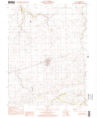
1998 Map of Kansas
USGS Topo · Published 2002About this map
The town of Kansas serves as the central hub for this late 20th-century survey of the Edgar and Coles county line. The settlement pattern is defined by a dense network of family and community landmarks, including the High Sch and Fairview Cem near the town center. The landscape is deeply carved by water, notably the North Fork Embarras River and the branching system of Donica Creek, including its east and west tributaries. This document provides exceptional detail for genealogists, recording numerous rural burial grounds such as Shields Cem, Wilhoit Cem, and Waite Cem. The transition from agrarian land to resource extraction is visible in the presence of an Oil Field tucked near the Coles Co Edgar Co border, while spiritual life is anchored by country parishes like Harmony Ch and Pleasant Hill Ch.
Find a feature on this map
24 named features on this map. Tap any name to fly to it.
Don’t see what you’re looking for? This feature index may not catch every label — zoom into the map to look around manually.
Map Details
Editions of this 1998 Kansas Map
This is the sole edition of this map. No revisions or reprints were ever made.
Other maps of this area

1933 · Toledo
USGS Topo · 1:62,500

1936 · Oakland
USGS Topo · 1:48,000

1936 · Casey
USGS Topo · 1:48,000

1938 · Toledo
USGS Topo · 1:62,500

1942 · Oakland
USGS Topo · 1:62,500

1942 · Casey
USGS Topo · 1:62,500

1943 · Casey
USGS Topo · 1:62,500

1946 · Kansas
USGS Topo · 1:62,500

1949 · Kansas
USGS Topo · 1:62,500

1953 · Indianapolis
USGS Topo · 1:250,000