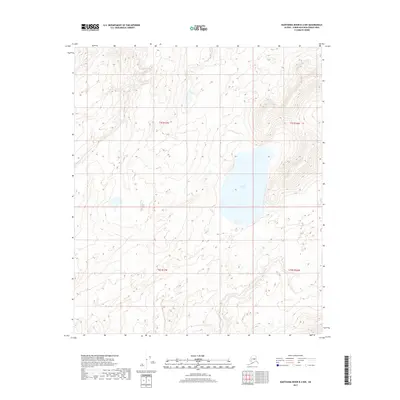
2017 Map of Kantishna River B-2 NW
USGS Topo · Published 2017About this map
W Twin Lake sits at the center of this remote landscape within the Alaska interior, dominated by a dense network of wetlands and complex topography. The map illustrates the sprawling lake systems and subtle elevation changes characteristic of the Unorganized Borough in the early 21st century. While human development is absent on this specific quadrangle, the survey meticulously records the Public Land Survey System boundaries, including the intersection of t5s r17w, t5s r16w, t6s r17w, and t6s r16w. This detail provides a clear view of the wilderness as it was documented by the U.S. Geological Survey in 2017, serving as a primary reference for the hydrologic patterns and land divisions of this subarctic terrain.
Find a feature on this map
5 named features on this map. Tap any name to fly to it.
Don’t see what you’re looking for? This feature index may not catch every label — zoom into the map to look around manually.
Map Details
Editions of this 2017 Kantishna River B-2 NW Map
This is the sole edition of this map. No revisions or reprints were ever made.
Other maps of this area

1948 · Kantishna River
USGS Topo · 1:250,000

1951 · Kantishna River
USGS Topo · 1:250,000

1952 · Kantishna River
USGS Topo · 1:250,000

1952 · Kantishna River C-3
USGS Topo · 1:63,360

1953 · Kantishna River B-2
USGS Topo · 1:63,360

1953 · Kantishna River B-3
USGS Topo · 1:63,360
1953 · Kantishna River C-2
USGS Topo · 1:63,360
1954 · Kantishna River C-2
USGS Topo · 1:63,360
1954 · Kantishna River C-3
USGS Topo · 1:63,360

1964 · Kantishna River
USGS Topo · 1:250,000