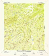
1954 Map of Kantishna River C-3
USGS Topo · Published 1956About this map
Mooseheart Mountain anchors the northeastern corner of this subarctic wilderness, rising above an intricate network of wetlands and braided waterways. This 1954 topographic survey, compiled from aerial photography, captures the meandering path of the Zitziana River as it winds through the central valley. The landscape is characterized by hundreds of small lakes and ponds, indicating a complex drainage system typical of the Tanana Valley permafrost regions. The absence of roads, buildings, or named settlements highlights the area's isolation during the mid-20th century, serving as a pristine baseline of the Alaskan interior before modern development or resource extraction occurred in this quadrant.
Find a feature on this map
2 named features on this map. Tap any name to fly to it.
Don’t see what you’re looking for? This feature index may not catch every label — zoom into the map to look around manually.
Map Details
Editions of this 1954 Kantishna River C-3 Map
This is the sole edition of this map. No revisions or reprints were ever made.
Other maps of this area

1948 · Kantishna River
USGS Topo · 1:250,000

1951 · Kantishna River
USGS Topo · 1:250,000

1952 · Kantishna River
USGS Topo · 1:250,000

1952 · Kantishna River D-2
USGS Topo · 1:63,360

1952 · Kantishna River D-3
USGS Topo · 1:63,360

1952 · Kantishna River C-3
USGS Topo · 1:63,360

1952 · Kantishna River C-4
USGS Topo · 1:63,360

1953 · Kantishna River B-2
USGS Topo · 1:63,360

1953 · Kantishna River B-4
USGS Topo · 1:63,360

1953 · Kantishna River B-3
USGS Topo · 1:63,360