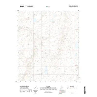
2017 Map of Kantishna River B-3 NE
USGS Topo · Published 2017About this map
Glacial landforms and an intricate network of wetlands define this portion of the Alaska interior within the Yukon-Koyukuk Census Area. This 2017 survey reveals a remote landscape primarily organized by the Public Land Survey System, with boundaries spanning T5s R18w, T5s R19w, and T5s R17w. The lack of named settlements or infrastructure highlights the wild character of the Kantishna River region, where topographic contours and hydrographic data from the National Hydrography Dataset provide the only markers of place. Township lines such as T6s R18w and T6s R19w serve as the primary identifiers for researchers and land managers navigating this expanse of the Unorganized Borough.
Find a feature on this map
6 named features on this map. Tap any name to fly to it.
Don’t see what you’re looking for? This feature index may not catch every label — zoom into the map to look around manually.
Map Details
Editions of this 2017 Kantishna River B-3 NE Map
This is the sole edition of this map. No revisions or reprints were ever made.
Other maps of this area

1948 · Kantishna River
USGS Topo · 1:250,000

1951 · Kantishna River
USGS Topo · 1:250,000

1952 · Kantishna River
USGS Topo · 1:250,000

1952 · Kantishna River C-3
USGS Topo · 1:63,360

1953 · Kantishna River B-2
USGS Topo · 1:63,360

1953 · Kantishna River B-3
USGS Topo · 1:63,360
1953 · Kantishna River C-2
USGS Topo · 1:63,360
1954 · Kantishna River C-2
USGS Topo · 1:63,360
1954 · Kantishna River C-3
USGS Topo · 1:63,360

1964 · Kantishna River
USGS Topo · 1:250,000